|
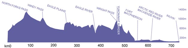
Elevation Line Profile Dempster Highway
|
During the 1999 Roads to Resources Expedition we traveled over
terrain unique to Canada. The Eagle Plains, a vast plateau
along the highway is one of the few places untouched by glaciation. Its
landscape has been shaped by erosion rather than scoured by
the firm grip of a glacier. Geologically an important area, significant
oil and gas explorations have taken place in the region. No
settlements existed over this section before the highway because of the
prohibitive costs of building on top of permafrost. However, the gas
station and motel at Eagle Plains has been constructed since the opening
of the highway. Built on a layer of bedrock, Eagle Plains boasts a
population of around 8 people. It is the only settlement between Dawson
City and Fort McPherson.
In winter there are two ice bridges along the Dempster- the first crosses the Peel River and the second spans Canada's longest river, the mighty MacKenzie. Although the Dempster ends in the town of Inuvik, 737 kilometers after it begins; during the winter, an opportunity exists to travel further north on an ice road that leads to the Arctic Ocean and the community of Tuktoyaktuk 200 kilometers to the north. The road travels over top of the MacKenzie River Delta and along the Tuktoyaktuk peninsula. |